Wandelkaarten - Lowlands | Schotse Laaglanden en grenzen
Overzichtskaarten
-
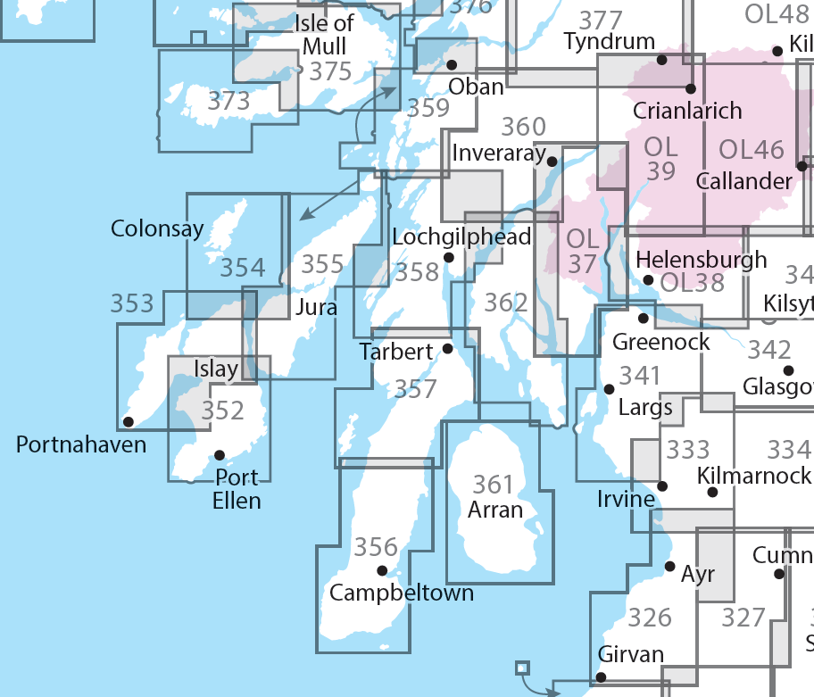
Overzichtskaart Explorer 25.000 wandelkaarten Zuidwest Schotland - Loch Lomond


Producten op deze overzichtskaart:
Klik op een product om naar de pagina van dat product te gaan.
- Wandelkaart - Topografische kaart 326 OS Explorer Map Ayr, Troon | Ordnance Survey
- Wandelkaart - Topografische kaart 327 OS Explorer Map Cumnock, Dalmellington | Ordnance Survey
- Wandelkaart - Topografische kaart 333 OS Explorer Map Kilmarnock, Irvine | Ordnance Survey
- Wandelkaart - Topografische kaart 341 OS Explorer Map Greenock, Largs, Millport | Ordnance Survey
- Wandelkaart - Topografische kaart 342 OS Explorer Map Glasgow | Ordnance Survey
- Wandelkaart - Topografische kaart 352 OS Explorer Map Islay South | Ordnance Survey
- Wandelkaart - Topografische kaart 353 OS Explorer Map Islay North | Ordnance Survey
- Wandelkaart - Topografische kaart 354 OS Explorer Map Colonsay, Oronsay | Ordnance Survey
- Wandelkaart - Topografische kaart 355 OS Explorer Map | Active Jura, Scarba | Ordnance Survey
- Wandelkaart - Topografische kaart 355 OS Explorer Map Jura, Scarba | Ordnance Survey
- Wandelkaart - Topografische kaart 356 OS Explorer Map Kintyre South | Ordnance Survey
- Wandelkaart - Topografische kaart 357 OS Explorer Map Kintyre North | Ordnance Survey
- Wandelkaart - Topografische kaart 358 OS Explorer Map Lochgilphead, Knapdale North | Ordnance Survey
- Wandelkaart - Topografische kaart 359 OS Explorer Map Oban, Kerrera, Loch Melfort | Ordnance Survey
- Wandelkaart - Topografische kaart 360 OS Explorer Map Loch Awe, Inveraray | Ordnance Survey
- Wandelkaart - Topografische kaart 361 OS Explorer Map | Active Isle of Arran | Ordnance Survey
- Wandelkaart 361 OS Explorer Map Isle of Arran | Ordnance Survey
- Wandelkaart - Topografische kaart 362 OS Explorer Map Cowal West, Isle of Bute | Ordnance Survey
- Wandelkaart - Topografische kaart 373 OS Explorer Map Iona, Staff, Ross of Mull | Ordnance Survey
- Wandelkaart - Topografische kaart 373 OS Explorer Map | Active Iona, Staffa, Ross of Mull | Ordnance Survey
- Wandelkaart - Topografische kaart 374 OS Explorer Map Isle of Mull North, Tobermroy | Ordnance Survey
- Wandelkaart - Topografische kaart 375 OS Explorer Map Isle of Mull East | Ordnance Survey
- Wandelkaart - Topografische kaart 377 OS Explorer Map Loch Etive, Glen Orchy Explorer | Ordnance Survey
- Wandelkaart - Topografische kaart OL37 OS Explorer Map Cowal East | Ordnance Survey
- Wandelkaart - Topografische kaart OL38 OS Explorer Map Loch Lomond South | Ordnance Survey
- Wandelkaart - Topografische kaart OL39 OS Explorer Map Loch Lomond North | Ordnance Survey
- Wandelkaart - Topografische kaart OL46 OS Explorer Map The Trossachs | Ordnance Survey
- Wandelkaart - Topografische kaart OL48 OS Explorer Map Ben Lawers & Glen Lyon | Ordnance Survey
-
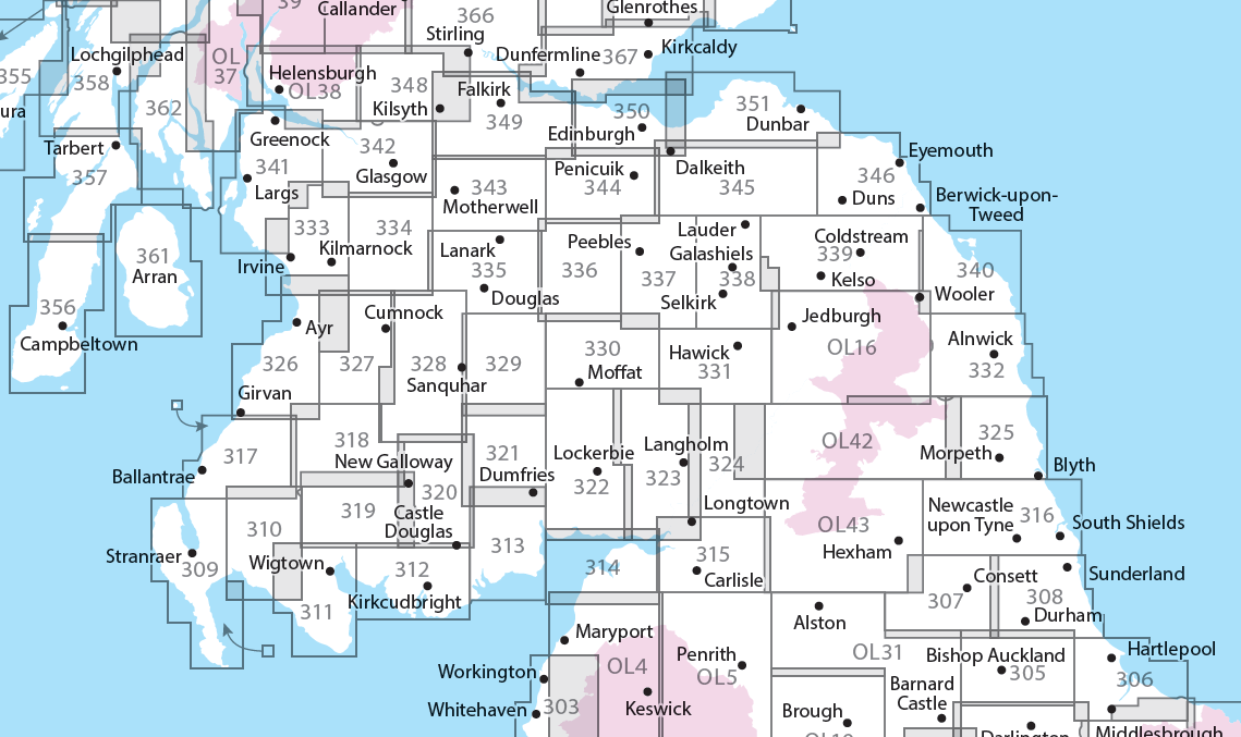
Overzichtskaart Explorer 25.000 wandelkaarten Zuid Schotland - Borders


Producten op deze overzichtskaart:
Klik op een product om naar de pagina van dat product te gaan.
- Wandelkaart - Topografische kaart 307 OS Explorer Map Consett, Derwent reservoir | Ordnance Survey
- Wandelkaart - Topografische kaart 308 OS Explorer Map Durham, Sunderland | Ordnance Survey
- Wandelkaart - Topografische kaart 309 OS Explorer Map Stranraer & The Rhins | Ordnance Survey
- Wandelkaart - Topografische kaart 310 OS Explorer Map Glenluce, Kirkcowan | Ordnance Survey
- Wandelkaart - Topografische kaart 311 OS Explorer Map Wigtown, Whithorn, The Machars | Ordnance Survey
- Wandelkaart - Topografische kaart 312 OS Explorer Map Kirkcudbright, Castle Douglas | Ordnance Survey
- Wandelkaart - Topografische kaart 313 OS Explorer Map Dumfries, Dalbeattie | Ordnance Survey
- Wandelkaart - Topografische kaart 314 OS Explorer Map Solway Firth, Wigton, Silloth explorer | Ordnance Survey
- Wandelkaart - Topografische kaart 315 OS Explorer Map Carlisle, Brampton, Longtown, Gretna Green | Ordnance Survey
- Wandelkaart - Topografische kaart 316 OS Explorer Map Newcastle upon Tyne | Ordnance Survey
- Wandelkaart - Topografische kaart 317 OS Explorer Map Ballantrae, Barr & Barrhill | Ordnance Survey
- Wandelkaart - Topografische kaart 318 OS Explorer Map Galloway Forest Park North | Ordnance Survey
- Wandelkaart - Topografische kaart 319 OS Explorer Map Galloway Forest Park South | Ordnance Survey
- Wandelkaart - Topografische kaart 320 OS Explorer Map Castle Douglas, Loch Ken, New Galloway | Ordnance Survey
- Wandelkaart - Topografische kaart 321 OS Explorer Map Nithsdale, Dumfries | Ordnance Survey
- Wandelkaart - Topografische kaart 322 OS Explorer Map Annandale | Ordnance Survey
- Wandelkaart - Topografische kaart 323 OS Explorer Map Eskdale, Castle O'er Forest | Ordnance Survey
- Wandelkaart - Topografische kaart 324 OS Explorer Map Liddesdale, Kershope Forest | Ordnance Survey
- Wandelkaart - Topografische kaart 325 OS Explorer Map Morpeth, Blyth | Ordnance Survey
- Wandelkaart - Topografische kaart 326 OS Explorer Map Ayr, Troon | Ordnance Survey
- Wandelkaart - Topografische kaart 327 OS Explorer Map Cumnock, Dalmellington | Ordnance Survey
- Wandelkaart - Topografische kaart 328 OS Explorer Map Sanquhar, New Cumnock | Ordnance Survey
- Wandelkaart - Topografische kaart 329 OS Explorer Map Lowther Hills, Sanquhar, Leadhills | Ordnance Survey
- Wandelkaart - Topografische kaart 330 OS Explorer Map Moffat, St Mary's Loch | Ordnance Survey
- Wandelkaart - Topografische kaart 331 OS Explorer Map Teviotdale South | Ordnance Survey
- Wandelkaart - Topografische kaart 332 OS Explorer Map Alnwick, Amble | Ordnance Survey
- Wandelkaart - Topografische kaart 333 OS Explorer Map Kilmarnock, Irvine | Ordnance Survey
- Wandelkaart - Topografische kaart 334 OS Explorer Map East Kilbride, Galston, Darvel | Ordnance Survey
- Wandelkaart - Topografische kaart 335 OS Explorer Map Lanark, Tinto Hills | Ordnance Survey
- Wandelkaart - Topografische kaart 336 OS Explorer Map Biggar, Broughton | Ordnance Survey
- Wandelkaart - Topografische kaart 337 OS Explorer Map Peebles, Interleithen | Ordnance Survey
- Wandelkaart - Topografische kaart 338 OS Explorer Map Galashiels, Selkirk, Melrose | Ordnance Survey
- Wandelkaart - Topografische kaart 339 OS Explorer Map Kelso, Coldstream, Lower Tweed Valley | Ordnance Survey
- Wandelkaart - Topografische kaart 340 OS Explorer Map Holy Island, Bamburgh | Ordnance Survey
- Wandelkaart - Topografische kaart 341 OS Explorer Map Greenock, Largs, Millport | Ordnance Survey
- Wandelkaart - Topografische kaart 342 OS Explorer Map Glasgow | Ordnance Survey
- Wandelkaart - Topografische kaart 343 OS Explorer Map Motherwell, Coatbridge | Ordnance Survey
- Wandelkaart - Topografische kaart 344 OS Explorer Map Pentland Hills | Ordnance Survey
- Wandelkaart - Topografische kaart 345 OS Explorer Map Lammermuir Hills | Ordnance Survey
- Wandelkaart - Topografische kaart 346 OS Explorer Map Berwick-upon-Tweed | Ordnance Survey
- Wandelkaart - Topografische kaart 349 OS Explorer Map Falkirk, Cumbernauld, Livingston | Ordnance Survey
- Wandelkaart - Topografische kaart 350 OS Explorer Map Edinburgh | Ordnance Survey
- Wandelkaart - Topografische kaart 351 OS Explorer Map Dunbar, North Berwick | Ordnance Survey
- Wandelkaart 361 OS Explorer Map Isle of Arran | Ordnance Survey
- Wandelkaart - Topografische kaart 361 OS Explorer Map | Active Isle of Arran | Ordnance Survey
- Wandelkaart - Topografische kaart 362 OS Explorer Map Cowal West, Isle of Bute | Ordnance Survey
- Wandelkaart - Topografische kaart OL16 OS Explorer Map Cheviot Hills | Ordnance Survey
- Wandelkaart - Topografische kaart OL42 OS Explorer Map Kielder Water & Forest | Ordnance Survey
- Wandelkaart - Topografische kaart OL43 OS Explorer Map Hadrian's Wall | Ordnance Survey
 Wandelkaart Southern Upland Way | Harvey Maps
Southern Upland Way is Britain's first official coast to coast long distance footpath and is one of Scotland's Great Trails. It runs 340km (212 miles) from Portpatrick on the south …
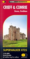
 Wandelkaart Crieff & Comrie, Doune, Dunblane | Harvey Maps
Map covers the Munro, Ben Chonzie, popular Glen Artney, as well as the Braes of Doune and Doune Castle, which has featured in various film and television shows, such as …
 Wandelkaart Ochil Hills | Harvey Maps
Superwalker is designed to be the most practical tool for navigation outdoors. The format gives more mapping on the sheet without making the map heavy and bulky. The fold has …
 Wandelkaart Pentland Hills | Harvey Maps
The whole of the Pentlands on one side of one sheet. More than a map, an essential piece of equipment this new generation HARVEY Superwalker is designed to be the …
 Wandelkaart Cheviot Hills | Harvey Maps
Includes the Cheviot, Newton Tors and Kirknewton. Detailed map for hillwalkers and cyclists of the Cheviot Hills at 1:25,000 scale. Includes the northern section of the Pennine Way from Brownhart …
 Wandelkaart Pentland Hills | Harvey Maps
Covers a large area yet is handily compact. Pocket perfect!Detailed map for runners and walkers of the whole of the Pentlands at the magic scale of 1:40,000 on one side …
 Wandelkaart Ochil Hills | Harvey Maps
Pocket perfect! Well known hills are Dumyat, Ben Cleuch and Castle Craig Hill. Magnificent views over the Forth Valley. Places of interest and enlargements of the steep and narrow glens: …
 Wandelkaart Arran | Harvey Maps
Covers a large area yet is handily compact. Pocket perfect! Features the renowned Goat Fell, A'Chir ridge, Beinn Bharrain, Glen Sannox & Glen Rosa. Detailed map for runners …
Laatste reviews

Heb de gids cadeau gedaan en die persoon was er heel blij mee ..
★★★★★ door J 21 november 2024 | Heeft dit artikel gekocht
De kaart van Kirgystan is prachtig, zeer gedetailleerd. Kan niet wachten tot de we echt op reis hmgaan die kant op.
★★★★★ door Marijke Eering 21 november 2024 | Heeft dit artikel gekocht
Super handig fiets boekje en mooi water bestendig. En handig om op de kaarten te kijken heel duidelijk beschrijving. Wij fietsen al jaren in Duitsland …
★★★★★ door Jenneke holterman 19 november 2024 | Heeft dit artikel gekocht
prima kaart levering en betaling allemaal vlot verlopen
★★★★★ door Marc Buts 19 november 2024 | Heeft dit artikel gekocht

