British Columbia
 Wandelkaart 08 Bragg Creek and Sheep Valley | Gem Trek Maps
Gem Trek’s BRAGG CREEK & SHEEP VALLEY MAP is for hikers and outdoor enthusiasts looking to explore Kananaskis Country west and south of Bragg Creek. Whether you are touring along …
 Wandelkaart 11 Banff Up-Close | Gem Trek Maps
Gem Trek Map-Guides Banff Up-Close (11) - This map-and-guide-in-one is designed for people who are only going to be in Banff for one to three days, and want to know …
 Wandelkaart 06 Canmore & Kananaskis Village | Gem Trek Maps
This map covers some of the most popular terrain for hikers and mountain bikers in Kananaskis Country - Bow Valley Provincial Park, the Canmore area, the Smith-Dorrien/Spray Lakes area south …
 Wandelkaart 14 Lake O'Hara | Gem Trek Maps
Mooie, gedetailleerde kaart uit de serie van Gem Trek Hiking map-guides, van het gebied Lake O'Hara. This is a detailed map of the Lake O'Hara area. On the front …
 Wegenkaart - landkaart - Wegenatlas Pan-Americana North | ITMB
Wegenatlas - A5 formaat - verschillende schalen - voor de het Noord-Amerikaanse gedeelte van de Pan-Americana ( Pan-American Highway ) van Alaska langs the Pacific kust van British Colombia in …
★★★★★ Wegenkaart - landkaart Icefields Parkway | Gem Trek Maps
Whether you have a day or a week to spend exploring the sights along the spectacular Icefields Parkway highway, Gem Trek's ICEFIELDS PAKRWAY MAP, a combination map and guide, will …
 Wandelkaart 02 Columbia Icefield | Gem Trek Maps
Waterproof and tear-resistant hiking and recreation map for the Columbia Icefield region of the Canadian Rockies. Updated with the latest satellite imagery of the icefield extent, Gem Trek's Columbia …
 Reisgids Eyewitness Travel USA- Canada the Pacific Northwest | Dorling Kindersley
Three-dimensional cutaway illustrations and floor plans of key landmarks complement these richly illustrated, fully updated travel handbooks that also include enhanced maps, street-by-street guides, background information on a host of …
★★★★★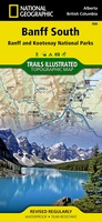 Wandelkaart 900 Banff South National Park | National Geographic
Prachtige geplastificeerde kaart van het bekende nationaal park. Met alle recreatieve voorzieningen als campsites, maar ook met topografische details en wandelroutes ed. Door uitgekiend kleurgebruik zeer prettig in gebruik. Scheur …
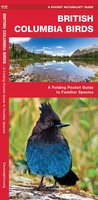 Vogelgids - Natuurgids British Columbia Birds | Waterford Press
British Columbia Birds, An Introduction to Familiar Species, is a must-have, reference guide for beginners and experts alike. This guide covers birding hotspots and sanctuaries. Whether you're on a nature …
★★★★★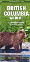 Natuurgids British Columbia Wildlife | Waterford Press
British Columbia Wildlife, An Introduction to Familiar Species, is a must-have reference guide for beginners and experts alike. Whether you're on a nature hike or taking a stroll in your …
★★★★★★★★★★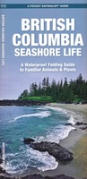 Natuurgids - Vogelgids British Columbia Seashore Life | Waterford Press
British Columbia Seashore Life, An Introduction to Familiar Plants and Animals, is a must-have, reference guide for beginners and experts alike. Whether you're hiking along the coast, relaxing at the …
★★★★★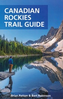 Wandelgids Canadian Rockies Trail Guide | Summerthought
The best loved and most detailed Canadian Rockies hiking guidebook is now in full color. First published in 1971 and now in its 10th edition, the Canadian Rockies Trail …
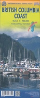 Wegenkaart - landkaart British Colombia Coast | ITMB
Een degelijke kaart met aanduidingen van o.a. nationale parken, vliegveld, benzinepomp, dirt-roads en kleine plattegrond van hoofdstad. As overzichtskaart goed te gebruiken. The home of the Haida nation is located …
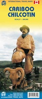 Wegenkaart - landkaart Cariboo Chilcotin (Canada - BC) | ITMB
ITMB is pleased to release the most recent recreational travel map for British Columbia, part of our goal of mapping this province comprehensively. The Cariboo district is immediately west of …
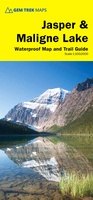 Wandelkaart 01 Jasper National Park & Maligne Lake | Gem Trek Maps
Scheur- en Watervast papier Gem Trek’s JASPER AND MALIGNE LAKE MAP map is designed for outdoor enthusiasts looking to explore the section of Jasper National Park near the town and …
★★★★★ Wegenkaart - landkaart Alaska's Inside Passage | ITMB
Een degelijke kaart met aanduidingen van o.a. nationale parken, vliegveld, benzinepomp, dirt-roads en kleine plattegronden van Anchorage, Seattle, Vancouver en Victoria. Als overzichtskaart goed te gebruiken. We recently released …
★★★★★ Reisgids British Columbia & the Canadian Rockies - Canada | Lonely Planet
De perfecte reisgids over British Columbia voor zowel de georganiseerde als de zelfstandige reiziger. Naast een algemene inleiding van het land / streek vol met praktische informatie over hoe je …
★★★★★ Reisgids Banff, Jasper and Glacier National Park | Lonely Planet
Uitgebreide beschrijving van alle recreatieve mogelijkheden van deze nationale parken. De perfecte reisgids voor zowel de georganiseerde als de zelfstandige reiziger. Naast een algemene inleiding van het land / streek …
★★★★★ Wegenkaart - landkaart Vancouver's North Shore Hiking Trails - Fraser Valley | ITMB
Our popular map showing the recreational hiking trails in the mountains within the urban area of Metro Vancouver, but outside of its urbanized limits, continues into its most recent printing …
- 1
- 2
- 3
- Volgende >>
- 4
Laatste reviews

Kan de huidige ontstuimige ontwikkelingen wereldwijd, nu ook geografisch plaatsen en daarmee beter volgen.
★★★★★ door Leo Janssen 20 december 2024 | Heeft dit artikel gekocht
We hadden Piëmonte al eens bezocht en voor onze komende reis werd ons door kennissen deze gids aanbevolen. Inderdaad is dit een heel goede gids. …
★★★★★ door DWKdB 19 december 2024 | Heeft dit artikel gekocht
Mijn bestellingen zijn altijd goed en worden altijd op tijd geleverd. Komen afspraken goed na. Erg tevreden.
★★★★★ door Ben Wegdam 19 december 2024 | Heeft dit artikel gekocht
Zeer gedetailleerde kaart van het zuidelijke deel van het douaniers pad
★★★★★ door Marian 18 december 2024 | Heeft dit artikel gekocht