Categorieën
- Nieuwe artikelen
- Boeken
-
Kaarten
- Camperkaarten
- Educatieve kaarten
- Fietskaarten
- Fietsknooppuntenkaarten
- Historische Kaarten
- Pelgrimsroutes (kaarten)
- Spoorwegenkaarten
- Stadsplattegronden
- Toerskikaarten
- Topografische kaarten
- Wandelatlassen
- Wandelkaarten
- Wandelknooppuntenkaarten
- Waterkaarten
- Wegenatlassen
-
Wegenkaarten
- Afrika
- Azië
-
Europa
- Albanië
- Andorra
- Armenië
- Azerbeidzjan
- Belarus - Witrusland
- België
- Bosnië - Hercegovina
- Bulgarije
- Cyprus
- Denemarken
- Duitsland
- Engeland
- Estland
- Faroer
- Finland
-
Frankrijk
- Picardie - Noordwest Frankrijk
- Hauts-de-France
- Grand-Est
- Champagne - Ardennen
- Normandië
- Bretagne
- Pays de la Loire
- Dordogne - Limousin
- Franse Atlantische Kust - Nouvelle-Aquitaine
- Aquitaine
- Limousin
- Poitou-Charentes
- Vogezen - Elzas - Lotharingen
- Île-de-France
- Bourgogne - Franche-Comté
- Franche-Comté
- Bourgondië
- Auvergne - Rhône-Alpes
- Auvergne
- Rhône-Alpes
- Franse Alpen
- Alpen - Mont Blanc - Haute Savoie
- Alpen - Vanoise - Savoie
- Alpen - Vaucluse - Drome - Vercors
- Pyreneeën
- Occitanie
- Languedoc - Rousillon
- Cevennen
- Midi-Pyrénées
- Centre - Val de Loire
- Provence - Alpes-Côte d’Azur
- Cote d'Azur - Franse Riviera
- Provence
- Corsica
- Lyon
- Parijs
- Rennes
- Straatsburg
- Georgië
- Griekenland
- Groenland
- Hongarije
- IJsland
- Ierland
- Italië
- Kosovo
- Kroatië
- Letland
- Liechtenstein
- Litouwen
- Luxemburg
- Malta
- Moldavië
- Monaco
- Montenegro
- Nederland
- Noord-Ierland
- Noord-Macedonië
- Noorwegen
- Oekraïne
- Oostenrijk
- Polen
- Portugal
- Roemenië
- Rusland
- Scandinavië
- Schotland
- Servië
- Slovenië
- Slowakije
- Spanje
- Tsjechië
- Turkije
- Vaticaanstad
- Zweden
- Zwitserland
- Midden-Amerika
- Midden-Oosten
- Noord-Amerika
- Oceanië
- Wereld
- Zuid-Amerika
- Wintersportkaarten
- Opruiming
- Puzzels
- Travel Gadgets
- Wandkaarten
- Wereldbollen
Veilig online betalen
Betaal veilig via uw eigen bankomgeving
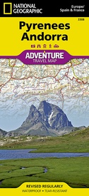
Wegenkaart - landkaart 3308 Adventure Map Pyrenees & Andorra - Pyreneeën en Andorra | National Geographic (9781566955409)
- ISBN / CODE: 9781566955409
- Editie: 01-12-2022
- Druk: 1
- Aantal blz.: 1
- Schaal: 1:275000
- Uitgever: National Geographic
- Soort: Wegenkaart
- Serie: Adventure Map
- Taal: Engels
- Hoogte: 24.0 cm
- Breedte: 11.0 cm
- Gewicht: 92.0 g
- Uitvoering: Scheur- en watervast
- Beoordeling: 5,0 ★★★★★ (1 review) Schrijf een review
-
€ 17,50
Op voorraad. Binnen 2 - 3 werkdagen in huis in Belgie Levertijd Nederland Voor 17.00 uur op werkdagen besteld, morgen in huis in Nederland Levertijd Belgie
Gratis verzending in Nederland vanaf €35,-
- Afbeeldingen
- Inkijkexemplaar
Beschrijving
Wegenkaart van de Pyreneeën en Andorra met vermelding van veel bezienswaardigheden, nationale parken en attrakties. Watervast en scheurvast. Juist door deze vermeldingen onderscheidt de kaart zich van andere wegenkaarten.
Reviews
Goede kaart en perfect geregeld
★★★★★ door Mulder 4 juni 2015Vond u dit een nuttige review? (login om te beoordelen)
Schrijf een review
Graag horen wij wat u van dit artikel vindt. Vindt u het goed, leuk, mooi, slecht, lelijk, onbruikbaar of erg handig: schrijf gerust alles op! Het is niet alleen leuk om te doen maar u informeert andere klanten er ook nog mee!
Ook interessant voor europa/frankrijk/pyreneeen
-

Reisgids PassePartout Prachtige Pyre
€ 24,50Reisgidsen Pyreneeën -

Wegenkaart - landkaart Pyreneeën Lan
€ 14,95Wegenkaarten Pyreneeën -

Wandelgids Frankreich: Jakobsweg Via
€ 20,50Wandelgidsen Pyreneeën -

Ansichtkaart Pyreneeën met reliëf |
€ 4,50Ansichtkaarten Pyreneeën -

Wandelkaart Pass'Aran - Couserans -
€ 16,95Wandelkaarten Ariège


