Wandelkaart - Topografische kaart 2613SB Château-Thierry, Charly-sur-Marne | IGN - Institut Géographique National (9782758549536)
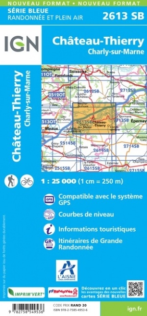
- ISBN / CODE: 9782758549536
- Editie: meest recente versie
- Schaal: 1:25000
- Uitgever: IGN - Institut Géographique National
- Soort: Topografische kaart, Wandelkaart
- Serie: Serie bleue
- Taal: Engels, Frans
- Beoordeling: 5,0 ★★★★★ (1 review) Schrijf een review
-
€ 16,95
Leverbaar in 3 - 5 werkdagen in huis in Nederland Levertijd Belgie
Gratis verzending in Nederland vanaf €35,-
-
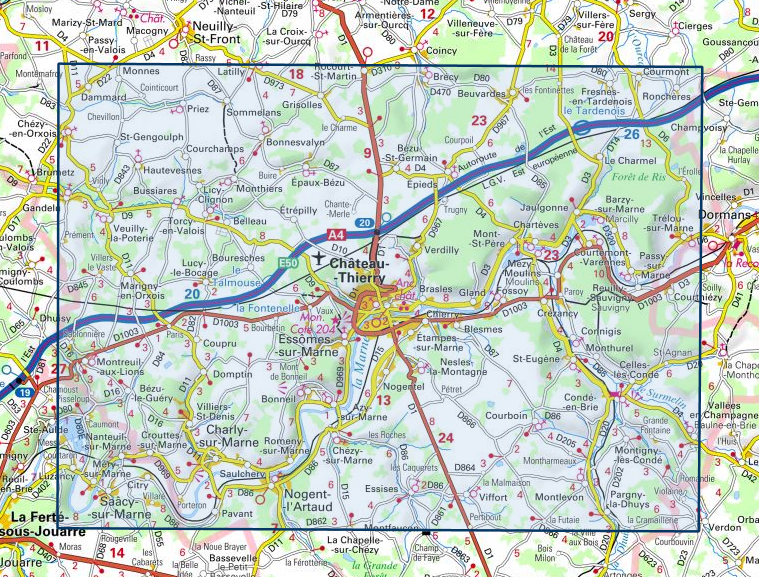
Overzicht IGN 25.000 Pays de Calais - Picardië: Zuid
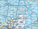

Producten op deze overzichtskaart:
Klik op een product om naar de pagina van dat product te gaan.
- Wandelkaart - Topografische kaart 2208SB Picquigny, Hallencourt, Molliens-Dreuil | IGN - Institut Géographique National
- Wandelkaart - Topografische kaart 2209SB Poix-de-Picardie, Hornoy-le-Bourg | IGN - Institut Géographique National
- Wandelkaart - Topografische kaart 2210SB Crèvecoeur-le-Grand, Grandvilliers | IGN - Institut Géographique National
- Wandelkaart - Topografische kaart 2211SB Gournay-en-Bray , Lachapelle-aux-Pots | IGN - Institut Géographique National
- Wandelkaart - Topografische kaart 2212SB Méru, Chaumont-en-Vexin | IGN - Institut Géographique National
- Wandelkaart - Topografische kaart 2308SB Corbie - Amiens | IGN - Institut Géographique National
- Wandelkaart - Topografische kaart 2309SB Moreuil - Saleux | IGN - Institut Géographique National
- Wandelkaart - Topografische kaart 2310SB Saint-Just-en-Chaussée , Breteuil | IGN - Institut Géographique National
- Wandelkaart - Topografische kaart 2311SB Beauvais - Mouy | IGN - Institut Géographique National
- Wandelkaart - Topografische kaart 2312ET Clermont - Creil | IGN - Institut Géographique National
- Wandelkaart - Topografische kaart 2408SB Bray-sur-Somme, Albert | IGN - Institut Géographique National
- Wandelkaart - Topografische kaart 2409SB Roye | IGN - Institut Géographique National
- Wandelkaart - Topografische kaart 2410SB Ressons-sur-Matz, Montdidier | IGN - Institut Géographique National
- Wandelkaart - Topografische kaart 2411SB Estrées-St-Denis, Clermont | IGN - Institut Géographique National
- Wandelkaart - Topografische kaart 2412OT Forêt de Chantilly | IGN - Institut Géographique National
- Wandelkaart - Topografische kaart 2508SB Roisel - Péronne | IGN - Institut Géographique National
- Wandelkaart - Topografische kaart 2509SB Ham - Nesle | IGN - Institut Géographique National
- Wandelkaart - Topografische kaart 2510SB Chauny - Noyon | IGN - Institut Géographique National
- Wandelkaart - Topografische kaart 2511OT Forêts de Compiègne | IGN - Institut Géographique National
- Wandelkaart - Topografische kaart 2512OT Villers-Cotterêts | IGN - Institut Géographique National
- Wandelkaart - Topografische kaart 2608SB Bohain-en-Vermandois, Guise | IGN - Institut Géographique National
- Wandelkaart - Topografische kaart 2609SB Ribemont - Saint Quentin | IGN - Institut Géographique National
- Wandelkaart - Topografische kaart 2610SB Tergnier, Forêt de St-Gobain et Coucy Basse | IGN - Institut Géographique National
- Wandelkaart - Topografische kaart 2611SB Braine - Soissons | IGN - Institut Géographique National
- Wandelkaart - Topografische kaart 2612SB Fère-en-Tardenois, Neuilly-St-Front | IGN - Institut Géographique National
- Wandelkaart - Topografische kaart 2613SB Château-Thierry, Charly-sur-Marne | IGN - Institut Géographique National
- Wandelkaart - Topografische kaart 2708SB Le Nouvion-en-Thiérache, Avesnes-sur-Helpe | IGN - Institut Géographique National
- Wandelkaart - Topografische kaart 2709SB Vervins - Marie | IGN - Institut Géographique National
- Wandelkaart - Topografische kaart 2710SB Sissonne - Laon | IGN - Institut Géographique National
- Wandelkaart - Topografische kaart 2808SB Hirson - Fourmies | IGN - Institut Géographique National
-
Overzicht IGN 25.000 Pays de Calais - Picardië: Zuid

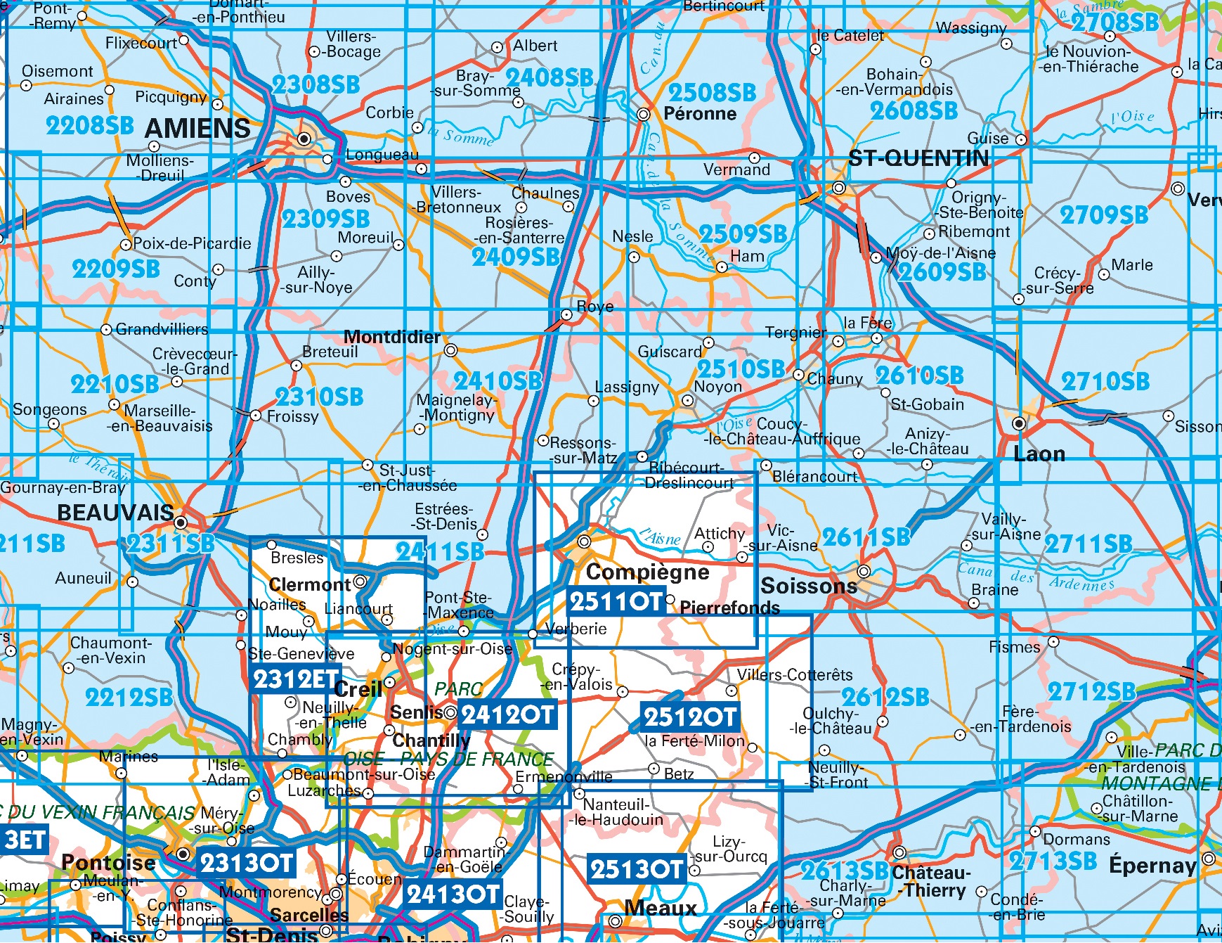
Producten op deze overzichtskaart:
Klik op een product om naar de pagina van dat product te gaan.
- Wandelkaart - Topografische kaart 2208SB Picquigny, Hallencourt, Molliens-Dreuil | IGN - Institut Géographique National
- Wandelkaart - Topografische kaart 2209SB Poix-de-Picardie, Hornoy-le-Bourg | IGN - Institut Géographique National
- Wandelkaart - Topografische kaart 2210SB Crèvecoeur-le-Grand, Grandvilliers | IGN - Institut Géographique National
- Wandelkaart - Topografische kaart 2211SB Gournay-en-Bray , Lachapelle-aux-Pots | IGN - Institut Géographique National
- Wandelkaart - Topografische kaart 2212SB Méru, Chaumont-en-Vexin | IGN - Institut Géographique National
- Wandelkaart - Topografische kaart 2308SB Corbie - Amiens | IGN - Institut Géographique National
- Wandelkaart - Topografische kaart 2309SB Moreuil - Saleux | IGN - Institut Géographique National
- Wandelkaart - Topografische kaart 2310SB Saint-Just-en-Chaussée , Breteuil | IGN - Institut Géographique National
- Wandelkaart - Topografische kaart 2311SB Beauvais - Mouy | IGN - Institut Géographique National
- Wandelkaart - Topografische kaart 2312ET Clermont - Creil | IGN - Institut Géographique National
- Wandelkaart - Topografische kaart 2408SB Bray-sur-Somme, Albert | IGN - Institut Géographique National
- Wandelkaart - Topografische kaart 2409SB Roye | IGN - Institut Géographique National
- Wandelkaart - Topografische kaart 2410SB Ressons-sur-Matz, Montdidier | IGN - Institut Géographique National
- Wandelkaart - Topografische kaart 2411SB Estrées-St-Denis, Clermont | IGN - Institut Géographique National
- Wandelkaart - Topografische kaart 2412OT Forêt de Chantilly | IGN - Institut Géographique National
- Wandelkaart - Topografische kaart 2508SB Roisel - Péronne | IGN - Institut Géographique National
- Wandelkaart - Topografische kaart 2509SB Ham - Nesle | IGN - Institut Géographique National
- Wandelkaart - Topografische kaart 2510SB Chauny - Noyon | IGN - Institut Géographique National
- Wandelkaart - Topografische kaart 2511OT Forêts de Compiègne | IGN - Institut Géographique National
- Wandelkaart - Topografische kaart 2512OT Villers-Cotterêts | IGN - Institut Géographique National
- Wandelkaart - Topografische kaart 2608SB Bohain-en-Vermandois, Guise | IGN - Institut Géographique National
- Wandelkaart - Topografische kaart 2609SB Ribemont - Saint Quentin | IGN - Institut Géographique National
- Wandelkaart - Topografische kaart 2610SB Tergnier, Forêt de St-Gobain et Coucy Basse | IGN - Institut Géographique National
- Wandelkaart - Topografische kaart 2611SB Braine - Soissons | IGN - Institut Géographique National
- Wandelkaart - Topografische kaart 2612SB Fère-en-Tardenois, Neuilly-St-Front | IGN - Institut Géographique National
- Wandelkaart - Topografische kaart 2613SB Château-Thierry, Charly-sur-Marne | IGN - Institut Géographique National
- Wandelkaart - Topografische kaart 2708SB Le Nouvion-en-Thiérache, Avesnes-sur-Helpe | IGN - Institut Géographique National
- Wandelkaart - Topografische kaart 2709SB Vervins - Marie | IGN - Institut Géographique National
- Wandelkaart - Topografische kaart 2710SB Sissonne - Laon | IGN - Institut Géographique National
- Wandelkaart - Topografische kaart 2808SB Hirson - Fourmies | IGN - Institut Géographique National
Overzichtskaarten
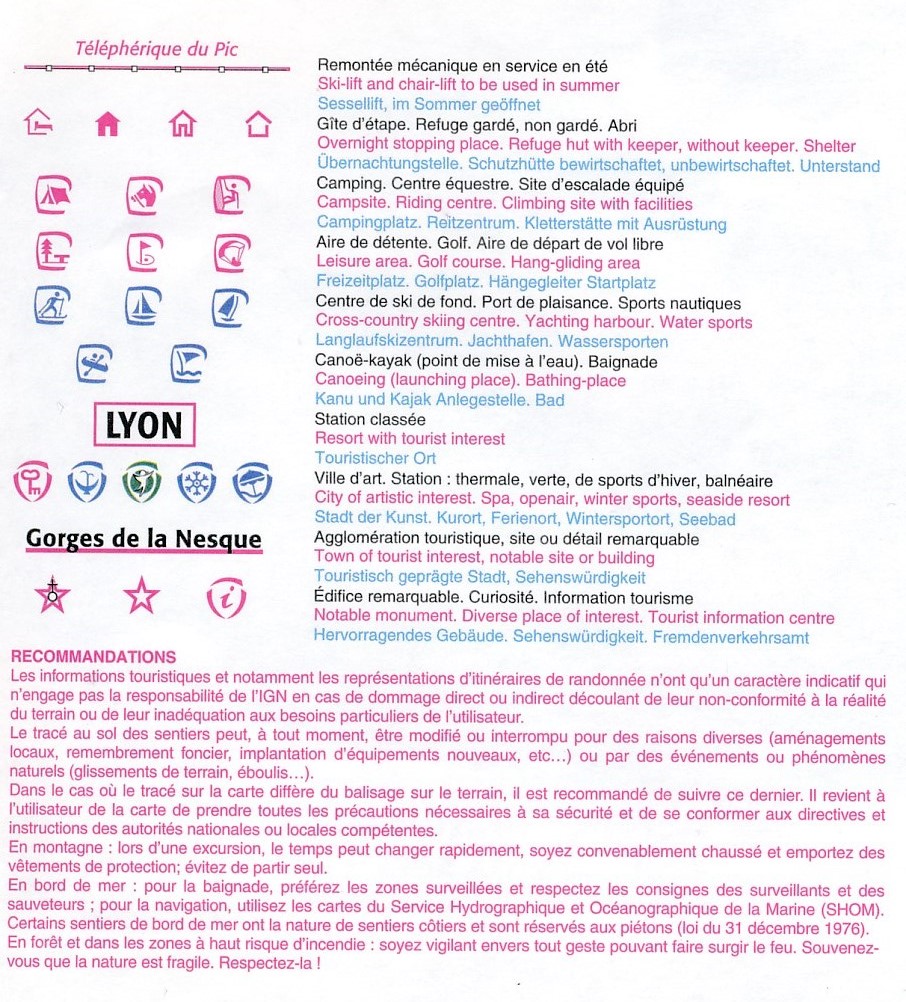
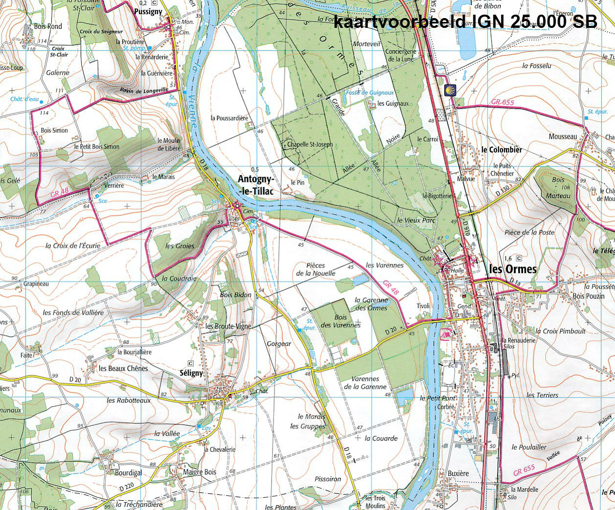
Beschrijving
Reviews
De kaart was prima. Waar ik vooral onder de indruk van ben is jullie service. De Zwerver medewerkster die ik aan de lijn had toen ik kaart van de Champagne bestelde heeft haar uiterste best gedaan om de kaart nog precies op tijd, voor ons vertrek, bij ons in de bus te krijgen. Daardoor is ons wandelweekend net even soepeler verlopen dan anders het geval geweest was. Nogmaals dank!
★★★★★ door Jolande Valk 31 juli 2021Vond u dit een nuttige review? (login om te beoordelen)
Schrijf een review
Graag horen wij wat u van dit artikel vindt. Vindt u het goed, leuk, mooi, slecht, lelijk, onbruikbaar of erg handig: schrijf gerust alles op! Het is niet alleen leuk om te doen maar u informeert andere klanten er ook nog mee!
Ook interessant voor europa/frankrijk/picardie-nw-frankrijk
-

Reisgids PassePartout Kleurrijk Pica
€ 24,50Reisgidsen Picardie - Noordwest Frankrijk -

Wandelkaart - Topografische kaart 25
€ 16,95Topografische kaarten Picardie - Noordwest Frankrijk -

Wandelkaart - Topografische kaart 25
€ 16,95Topografische kaarten Picardie - Noordwest Frankrijk -

Fietskaart 39 Fietsroute-Netwerk Ar
€ 12,50Fietskaarten Picardie - Noordwest Frankrijk -

Wandelgids Marais d'Opale côte | Cha
€ 11,95Wandelgidsen Picardie - Noordwest Frankrijk