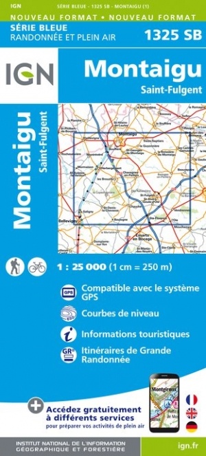
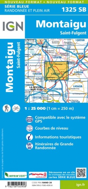
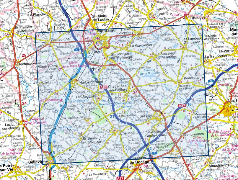
Wandelkaart - Topografische kaart 1325SB Montaigu | IGN - Institut Géographique National (9782758545958)
Saint-Fulgent
- ISBN / CODE: 9782758545958
- Editie: meest recente versie
- Schaal: 1:25000
- Uitgever: IGN - Institut Géographique National
- Soort: Topografische kaart, Wandelkaart
- Serie: Serie bleue
- Taal: Engels, Frans
- Bindwijze: -
- Uitvoering: Papier
- Schrijf als eerste een review
-
€ 16,95
Leverbaar in 3 - 5 werkdagen in huis in Nederland Levertijd Belgie
Gratis verzending in Nederland vanaf €35,-
-
Topografische kaarten IGN 25.000 Loire - Centre: KUST - WESTELIJK GEDEELTE Angers - Nantes

Producten op deze overzichtskaart:
Klik op een product om naar de pagina van dat product te gaan.
- Wandelkaart - Topografische kaart 1123OT Saint-Nazaire - Pornic – Cote de Jade | IGN - Institut Géographique National
- Topografische kaart - Wandelkaart 1124SB Saint-Étienne-de-Montluc | IGN - Institut Géographique National
- Wandelkaart - Topografische kaart 1125OT Ile de Noirmoutier, Beauvoir-sur-Mer & Bourgneuf-en-Ret | IGN - Institut Géographique National
- Wandelkaart - Topografische kaart 1125SB Challans, Machecoul-Saint-Même | IGN - Institut Géographique National
- Wandelkaart - Topografische kaart 1126OT Ile d'Yeu, Saint-Gilles-Croix-de-Vie & Saint-Jean-de-Mont | IGN - Institut Géographique National
- Wandelkaart - Topografische kaart 1221SB Guémené – Penfao – Nozay | IGN - Institut Géographique National
- Wandelkaart - Topografische kaart 1222SB Blain - Nort-sur-Erdre | IGN - Institut Géographique National
- Topografische kaart - Wandelkaart 1223SB Nantes - St Herblain | IGN - Institut Géographique National
- Topografische kaart - Wandelkaart 1224SB St-Philbert-de-Grand-Lieu, Les Sorinières | IGN - Institut Géographique National
- Wandelkaart - Topografische kaart 1225SB Legé | IGN - Institut Géographique National
- Wandelkaart - Topografische kaart 1226SB Le Poiré-sur-Vie, Aizenay, La Mothe-Achard | IGN - Institut Géographique National
- Wandelkaart - Topografische kaart 1227OT Les Sables-d' Olonne | IGN - Institut Géographique National
- Wandelkaart - Topografische kaart 1227SB Aubigny-les-Clouzeaux | IGN - Institut Géographique National
- Wandelkaart - Topografische kaart 1321SB Saint-Mars-la-Jaille – Moisdon-la-Rivière | IGN - Institut Géographique National
- Topografische kaart - Wandelkaart 1322SB Ancenis | IGN - Institut Géographique National
- Topografische kaart - Wandelkaart 1323SB Vallet | IGN - Institut Géographique National
- Wandelkaart - Topografische kaart 1324SB Clisson | IGN - Institut Géographique National
- Wandelkaart - Topografische kaart 1325SB Montaigu | IGN - Institut Géographique National
- Wandelkaart - Topografische kaart 1326SB La Roche-sur-Yon | IGN - Institut Géographique National
- Wandelkaart - Topografische kaart 1327SB Luçon | IGN - Institut Géographique National
- Wandelkaart - Topografische kaart 1328OT La Tranche-sur-Mer & Laiguillon-sur-Mer | IGN - Institut Géographique National
- Wandelkaart - Topografische kaart 1421SB Segré | IGN - Institut Géographique National
- Wandelkaart - Topografische kaart 1422SB Chalonnes-sur-Loire | IGN - Institut Géographique National
- Wandelkaart - Topografische kaart 1423SB Chemillé-Melay | IGN - Institut Géographique National
- Wandelkaart - Topografische kaart 1424SB Cholet | IGN - Institut Géographique National
- Wandelkaart - Topografische kaart 1425SB Les Herbiers | IGN - Institut Géographique National
- Wandelkaart - Topografische kaart 1426SB Chantonnay | IGN - Institut Géographique National
- Wandelkaart - Topografische kaart 1427SB Fontenay-le-Comte | IGN - Institut Géographique National
- Wandelkaart - Topografische kaart 1428SB Marans | IGN - Institut Géographique National
- Wandelkaart - Topografische kaart 1520SB Château-Gontier | IGN - Institut Géographique National
- Wandelkaart - Topografische kaart 1521SB le Lion-d'Angers | IGN - Institut Géographique National
- Wandelkaart - Topografische kaart 1522ET Angers | IGN - Institut Géographique National
- Wandelkaart - Topografische kaart 1523SB Thouarcé | IGN - Institut Géographique National
- Topografische kaart - Wandelkaart 1524SB Vihiers | IGN - Institut Géographique National
- Topografische kaart - Wandelkaart 1525SB Bressuire | IGN - Institut Géographique National
- Wandelkaart - Topografische kaart 1526SB Moncoutant - La Chapelle-Saint-Laurent | IGN - Institut Géographique National
- Wandelkaart - Topografische kaart 1527SB Coulonges-sur-l'Autize, Secondigny | IGN - Institut Géographique National
- Topografische kaart - Wandelkaart 1620SB La Flèche | IGN - Institut Géographique National
- Topografische kaart - Wandelkaart 1621SB Baugé-en-Anjou | IGN - Institut Géographique National
- Topografische kaart - Wandelkaart 1622SB Longué-Jumelles, Beaufort-en-Vallée | IGN - Institut Géographique National
- Topografische kaart - Wandelkaart 1623SB Saumur | IGN - Institut Géographique National
- Topografische kaart - Wandelkaart 1624SB Thouars | IGN - Institut Géographique National
- Topografische kaart - Wandelkaart 1625SB Thouars | IGN - Institut Géographique National
- Wandelkaart - Topografische kaart 1626SB Parthenay - Thenezay | IGN - Institut Géographique National
- Topografische kaart - Wandelkaart 1721SB le Lude | IGN - Institut Géographique National
- Topografische kaart - Wandelkaart 1722SB Savigné-sur-Lathan, Noyant | IGN - Institut Géographique National
- Wandelkaart - Topografische kaart 1723ET Chinon | IGN - Institut Géographique National
-
Wandelkaarten IGN 25.000 Loire - Centre: KUST - WESTELIJK GEDEELTE Angers - Nantes

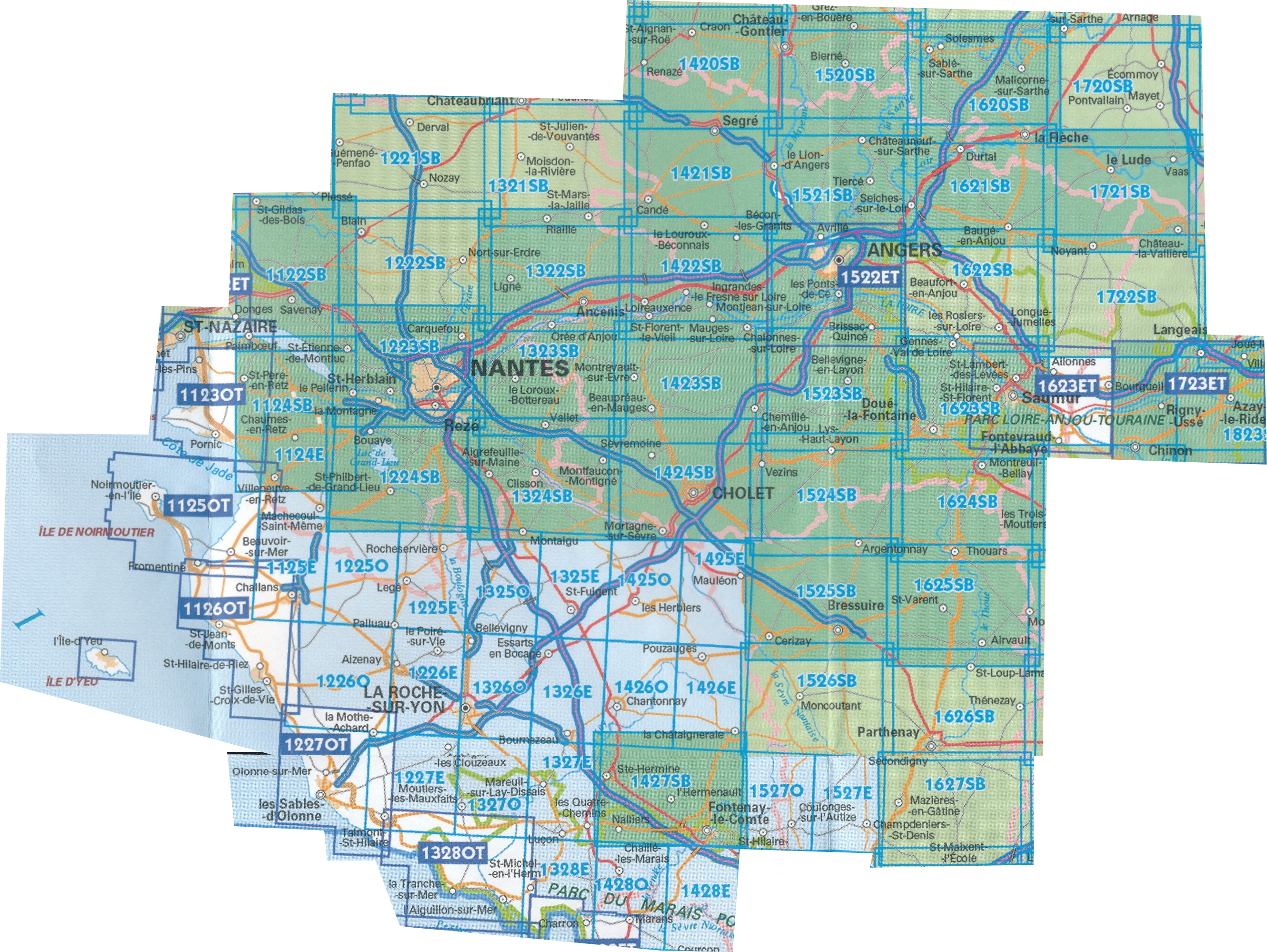
Producten op deze overzichtskaart:
Klik op een product om naar de pagina van dat product te gaan.
- Wandelkaart - Topografische kaart 1123OT Saint-Nazaire - Pornic – Cote de Jade | IGN - Institut Géographique National
- Topografische kaart - Wandelkaart 1124SB Saint-Étienne-de-Montluc | IGN - Institut Géographique National
- Wandelkaart - Topografische kaart 1125OT Ile de Noirmoutier, Beauvoir-sur-Mer & Bourgneuf-en-Ret | IGN - Institut Géographique National
- Wandelkaart - Topografische kaart 1125SB Challans, Machecoul-Saint-Même | IGN - Institut Géographique National
- Wandelkaart - Topografische kaart 1126OT Ile d'Yeu, Saint-Gilles-Croix-de-Vie & Saint-Jean-de-Mont | IGN - Institut Géographique National
- Wandelkaart - Topografische kaart 1221SB Guémené – Penfao – Nozay | IGN - Institut Géographique National
- Wandelkaart - Topografische kaart 1222SB Blain - Nort-sur-Erdre | IGN - Institut Géographique National
- Topografische kaart - Wandelkaart 1223SB Nantes - St Herblain | IGN - Institut Géographique National
- Topografische kaart - Wandelkaart 1224SB St-Philbert-de-Grand-Lieu, Les Sorinières | IGN - Institut Géographique National
- Wandelkaart - Topografische kaart 1225SB Legé | IGN - Institut Géographique National
- Wandelkaart - Topografische kaart 1226SB Le Poiré-sur-Vie, Aizenay, La Mothe-Achard | IGN - Institut Géographique National
- Wandelkaart - Topografische kaart 1227OT Les Sables-d' Olonne | IGN - Institut Géographique National
- Wandelkaart - Topografische kaart 1227SB Aubigny-les-Clouzeaux | IGN - Institut Géographique National
- Wandelkaart - Topografische kaart 1321SB Saint-Mars-la-Jaille – Moisdon-la-Rivière | IGN - Institut Géographique National
- Topografische kaart - Wandelkaart 1322SB Ancenis | IGN - Institut Géographique National
- Topografische kaart - Wandelkaart 1323SB Vallet | IGN - Institut Géographique National
- Wandelkaart - Topografische kaart 1324SB Clisson | IGN - Institut Géographique National
- Wandelkaart - Topografische kaart 1325SB Montaigu | IGN - Institut Géographique National
- Wandelkaart - Topografische kaart 1326SB La Roche-sur-Yon | IGN - Institut Géographique National
- Wandelkaart - Topografische kaart 1327SB Luçon | IGN - Institut Géographique National
- Wandelkaart - Topografische kaart 1328OT La Tranche-sur-Mer & Laiguillon-sur-Mer | IGN - Institut Géographique National
- Wandelkaart - Topografische kaart 1421SB Segré | IGN - Institut Géographique National
- Wandelkaart - Topografische kaart 1422SB Chalonnes-sur-Loire | IGN - Institut Géographique National
- Wandelkaart - Topografische kaart 1423SB Chemillé-Melay | IGN - Institut Géographique National
- Wandelkaart - Topografische kaart 1424SB Cholet | IGN - Institut Géographique National
- Wandelkaart - Topografische kaart 1425SB Les Herbiers | IGN - Institut Géographique National
- Wandelkaart - Topografische kaart 1426SB Chantonnay | IGN - Institut Géographique National
- Wandelkaart - Topografische kaart 1427SB Fontenay-le-Comte | IGN - Institut Géographique National
- Wandelkaart - Topografische kaart 1428SB Marans | IGN - Institut Géographique National
- Wandelkaart - Topografische kaart 1520SB Château-Gontier | IGN - Institut Géographique National
- Wandelkaart - Topografische kaart 1521SB le Lion-d'Angers | IGN - Institut Géographique National
- Wandelkaart - Topografische kaart 1522ET Angers | IGN - Institut Géographique National
- Wandelkaart - Topografische kaart 1523SB Thouarcé | IGN - Institut Géographique National
- Topografische kaart - Wandelkaart 1524SB Vihiers | IGN - Institut Géographique National
- Topografische kaart - Wandelkaart 1525SB Bressuire | IGN - Institut Géographique National
- Wandelkaart - Topografische kaart 1526SB Moncoutant - La Chapelle-Saint-Laurent | IGN - Institut Géographique National
- Wandelkaart - Topografische kaart 1527SB Coulonges-sur-l'Autize, Secondigny | IGN - Institut Géographique National
- Topografische kaart - Wandelkaart 1620SB La Flèche | IGN - Institut Géographique National
- Topografische kaart - Wandelkaart 1621SB Baugé-en-Anjou | IGN - Institut Géographique National
- Topografische kaart - Wandelkaart 1622SB Longué-Jumelles, Beaufort-en-Vallée | IGN - Institut Géographique National
- Topografische kaart - Wandelkaart 1623SB Saumur | IGN - Institut Géographique National
- Topografische kaart - Wandelkaart 1624SB Thouars | IGN - Institut Géographique National
- Topografische kaart - Wandelkaart 1625SB Thouars | IGN - Institut Géographique National
- Wandelkaart - Topografische kaart 1626SB Parthenay - Thenezay | IGN - Institut Géographique National
- Topografische kaart - Wandelkaart 1721SB le Lude | IGN - Institut Géographique National
- Topografische kaart - Wandelkaart 1722SB Savigné-sur-Lathan, Noyant | IGN - Institut Géographique National
- Wandelkaart - Topografische kaart 1723ET Chinon | IGN - Institut Géographique National
Overzichtskaarten
Beschrijving
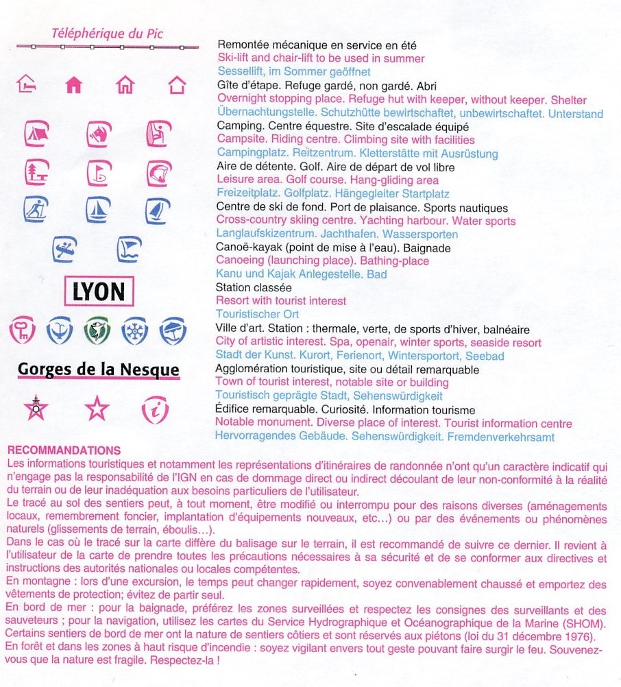
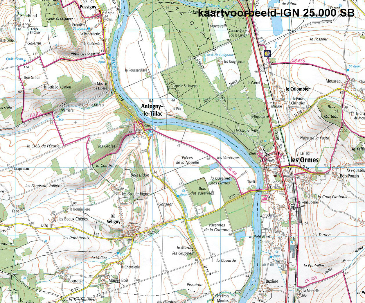
De wandelkaart die de perfectie benadert! Werkelijk alle topografische details zijn er op te vinden; van hoogtelijnen tot aan bruggetjes en allerlei wandelpaden. Daarnaast hebben de makers een flinke dosis toeristische informatie op de kaart verwerkt: campings, gites d étape en ingetekende doorgaande wandelpaden, de grandes randonnées. Het kleurgebruik is geweldig met schaduwzijdes, bos, weiland, etc goed te onderscheiden. De kaart is uitgevoerd met raster van graden, dus deze is GPS - toepasbaar!
De TOP 25 kaarten (kaart nummers die eindigen op "T") hebben betrekking op gebieden van bijzonder toeristisch belang zoals de Alpen, de Pyreneeën,De Cevennes, de Vogezen, de Provence, en de Atlantische en Middellandse zeekusten. De kaarten hebben een opdruk en benadrukken zo de lokale wandelpaden, lange afstand GR routes en, in voorkomend geval, ski routes. Andere toeristische informatie omvat campings, paardensport of kanocentra, hutten, berghutten, etc. Elke "TOP 25" kaart bedekt een gebied van ongeveer 28 x 21 km.
Reviews
Geen reviews gevonden voor dit product.
Schrijf een review
Graag horen wij wat u van dit artikel vindt. Vindt u het goed, leuk, mooi, slecht, lelijk, onbruikbaar of erg handig: schrijf gerust alles op! Het is niet alleen leuk om te doen maar u informeert andere klanten er ook nog mee!
Ook interessant voor europa/frankrijk/loire-centre
-

Wandelgids D086 La Vienne... à pied
€ 18,50Wandelgidsen Centre - Val de Loire -

Reisgids Loire - Frankrijk binnendoo
€ 22,50Reisgidsen Centre - Val de Loire -

Wandelkaart - Topografische kaart 19
€ 16,95Topografische kaarten Centre - Val de Loire -

Fietskaart - Wegenkaart - landkaart
€ 10,95Fietskaarten Centre - Val de Loire -

Wandelgids P433 Le Pays de l'Emblave
€ 14,95Wandelgidsen Centre - Val de Loire