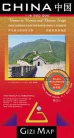
Wegenkaart - landkaart China Administrative Map | Gizi Map (9789638680860)
- ISBN / CODE: 9789638680860
- Editie: 20-10-2018
- Aantal blz.: 1
- Schaal: 1:6500000
- Uitgever: Gizi Map
- Soort: Wegenkaart
- Taal: Engels
- Hoogte: 24.0 cm
- Breedte: 13.0 cm
- Gewicht: 88.0 g
- Uitvoering: Papier
- Schrijf als eerste een review
-
€ 15,95
Leverbaar in 3 - 5 werkdagen in huis in Belgie Levertijd Nederland
Beschrijving
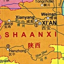
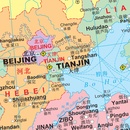
This folded, political map of China shows provinces in different colors. Map features province boundaries, major cities, airports, waterways, ports and the Great Wall. Inset of Pearl River Delta. Legend in 5 languages: English, German, French, Italian, and Chinese. Scale is 1:6.5 million.
A basic political map of the country, with colours clearly distinguishing the provinces. Major towns and rivers are identified and the great wall is marked. Symbols depict airports and ports. Manes are written in Roman and Chinese script. An inset shows Hong Kong and the Pearl River Delta region at 1:1,000,000
Reviews
Geen reviews gevonden voor dit product.
Schrijf een review
Graag horen wij wat u van dit artikel vindt. Vindt u het goed, leuk, mooi, slecht, lelijk, onbruikbaar of erg handig: schrijf gerust alles op! Het is niet alleen leuk om te doen maar u informeert andere klanten er ook nog mee!


