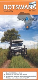
Wegenkaart - landkaart Botswana | Tracks4Africa (9781776322824)
- ISBN / CODE: 9781776322824
- Editie: 22-05-2024
- Druk: 5
- Aantal blz.: 1
- Schaal: 1:1000000
- Uitgever: Tracks4Africa
- Soort: Wegenkaart
- Taal: Engels
- Hoogte: 29.0 cm
- Breedte: 14.0 cm
- Gewicht: 142.0 g
- Bindwijze: -
- Uitvoering: Scheur- en watervast
- Beoordeling: 4,6 ★★★★★ ★★★★★ (14 reviews) Schrijf een review
-
€ 27,50
Op voorraad. Voor 17.00 uur op werkdagen besteld, morgen in huis in Nederland Levertijd Belgie
Gratis verzending in Nederland vanaf €35,-
Beschrijving
Uitstekende wegenkaart van Botswana, gemaakt door gerenommeerde kaartenmaker Tracks4Africa in Afrika. Met afstanden en reistijden tussen steden en op alle wegen vermeld. GPS via hun website te downloaden.
The Tracks4Africa Botswana paper map, now in its 4th edition, is designed to be used in conjunction with the T4A GPS Map of Botswana. It is the largest available Botswana map at 1:1,000,000 scale, offering you the perfect trip planning tool for your next Botswana holiday.
- Printed on tear proof and water resistant Polyart
- Scale 1:1,000,000 (1cm = 10km)
- All roads have been driven by the Tracks4Africa Community
- Map key included
- Map index included
- Detailed vector maps of the Okavango Delta, Mabuasehube, Savuti, Gaborone, Maun, Kasane, Khwai East and West
- Travel information like border post red tape, camping etiquette, driving in Botswana, fuel, useful contact numbers etc.
- Distances and travel times between towns are indicated
- Main services indicated with icons in main towns
- Border Controls with opening and closing times
- Detailed maps eg. Gaborone
Reviews
goed en op tijd
★★★★★ door graaf.hooidonk@hccnet.nl 10 april 2024Vond u dit een nuttige review? (login om te beoordelen)
Prachtige kaart. Voorpret en uitstippelen kon meteen beginnen bij het ontvangen van de kaart. Kaart is heel groot en duidelijk, voorzien van een vuil- en vochtafstotend laagje, super handig dus. Oh ja, de afstanden en verwachte reistijden staan er ook op! Levering zoals we gewend zijn, snel en netjes.
★★★★★ door Jenny 2 augustus 2023Vond u dit een nuttige review? (login om te beoordelen)
De kaart is erg groot wat in de auto niet erg handig, We hebben tijdens de reis in Botswana deze kaart en ook nog setje hele oude shell kaarten en ik moet zeggen dat ik vooral in de parken de shell kaarten beter/duidelijker vind. Voor het plannen van een route is deze kaart wel geschikt omdat niet alleen de afstand maar ook de globale reisduur staat aangeven.
★★★★★ door Patrick 15 oktober 2018Vond u dit een nuttige review? (login om te beoordelen)
Schrijf een review
Graag horen wij wat u van dit artikel vindt. Vindt u het goed, leuk, mooi, slecht, lelijk, onbruikbaar of erg handig: schrijf gerust alles op! Het is niet alleen leuk om te doen maar u informeert andere klanten er ook nog mee!


